
Page 6 - Muzaffargarh Gazzetteer
P. 6
Chapter 1
GENERAL INFORMATION
Muzaffargarh – the fort of Muzaffargarh – was founded in 1794, i.e. exactly
225 years ago, by the then ruler of Multan, Nawab Muzaffar Khan. Prior to
that, the place was known as ‘Musan de Hatti’ and was a stopover for those
who travelled between Multan and Dera Ghazi Khan, and beyond. The
district has a unique geography as it is triangular in shape and is bounded
by two rivers, i.e. Chenab on the east and Indus on the west. It shares
boundaries with Rajanpur in the south-west, Dera Ghazi Khan in the north-
west, Khanewal, Multan and Bahawalpur in the east, Layyah in the north,
and Rahim Yar Khan in the south.
The district comprises 4 tehsils, i.e. Muzaffargarh, Kot Addu, Alipur and
Jatoi. Previously, Layyah too was a tehsil of Muzaffargarh but it was
separated and made into a new district in 1982.
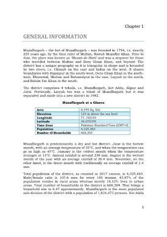
Muzaffargarh at a Glance
Area 8,249 Sq. Km
Elevation 123 m above the sea level
Longitude 71.192130
Latitude 30.075370
Time Zone Pakistan Standard Time (GMT+5)
Population 4,325,483
Number of Households 668,204
Muzaffargarh is predominantly a dry and hot district. June is the hottest
month, with an average temperature of 35°C, and when the temperature can
go as high as 45°C. January is the coldest month when the temperature
averages at 13°C. Annual rainfall is around 236 mm. August is the wettest
month of the year with an average rainfall of 36.4 mm. November, on the
other hand, is the driest month with traditionally an average rainfall of 1.4
mm.
Total population of the district, as counted in 2017 census, is 4,325,483.
Male/female ratio is 105.6 men for every 100 women. 83.87% of the
population resides in rural areas whereas merely 16.13% lives in urban
areas. Total number of households in the district is 668,204. That brings a
household size to 6.47 approximately. Muzaffargarh is the most populated
sub-division of the district with a population of 1,624,472 persons. Kot Addu
1